Thursday, 21 July 2011

Ruins and Rivers - Easby and Egglestone Abbeys

Driving around the region takes you by countless remnants of times gone by - ruined castles at Richmond, Barnard Castle and Brough, former mining buildings such as Crackpot Hall up in Swaledale and collapsed buildings such as the lavishly named Ravock Castle high on Bowes Moor. There is also plenty evidence of monastic life remaining and I recently explored a couple of these sites - Egglestone Abbey near Barnard Castle and Easby Abbey near Richmond.


Both are ruined Premonstratensian Abbeys, founded in the 12th Century. The monks wore white habits and became to be know as White Canons, living a lifestyle similar to that of Cistercian monks. Within 15 miles of each other, the two abbeys were to suffer a similar fate. Ultimately brought to closure and abandonment by Henry VIII's dissolution, they also both suffered heavily from Scottish raids as well as at the hands of the English army.

Today both sites are managed by the English Heritage.

Egglestone Abbey church

I made an unscheduled visit to Egglestone Abbey, whilst on the way to High Force. The site lays on the Teesdale Way and there was no shortage of walkers passing. I think before long I will be doing a section of this walk heading from here to Cotherstone via Barnard Castle - watch this space...


Egglestone Abbey occupies a great spot, a short distance from the southern bank of the Tees, nestled between hills and fields. The ruins are fairly spectacular and it is amazing how much of the stonework has survived. The site is well preserved with a number of graves and tombstones still intact and some stonework on the ground giving you an impression of how the buildings might once have been.
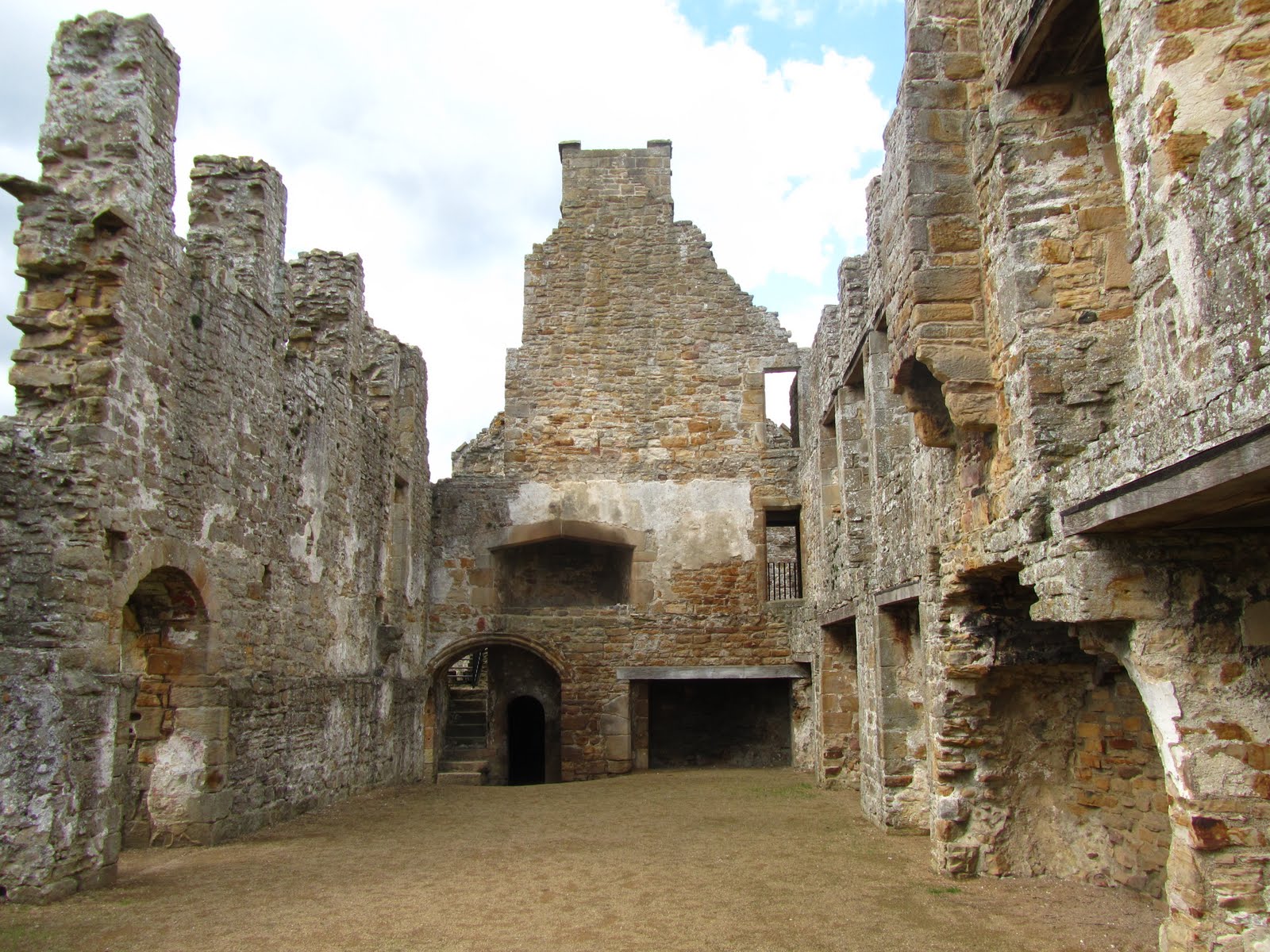
Egglestone Abbey dayrooms with dormitory above

Leaving the Tees, we now head over to Swaledale and Easby Abbey, just outside of Richmond.


Having visited Easby Abbey a few years ago, it was a pleasant surprise to find that there were many new information boards dotted around the site explaining what all the buildings originally were.


You can do a very pleasant circular walk from Richmond, I started at the station and followed the footpath along the old railway line for a mile or so. This takes you along rural Richmond, and shortly you catch glimpses of Easby Abbey between the trees to your left. Coming up to the river Swale you may have to hold your nose for a short distance as you go past the sewage works - depending on the direction the wind is blowing...this is one of the few moments that having a blocked nose worked to my advantage.


You get a great view of the river from the bridge before following a woodland path for the remaining distance to Easby, coming out of the woods just before St. Agatha's Church church and with the Abbey nestled behind the church. It is a huge site, and must have been very impressive when it was standing. You can walk all around the site and as I mentioned there is a lot of information available.


The return section of the walk goes through a field before rejoining the woodland path along the river, coming into Richmond passing the Drummer Boy Stone. You can read about the legend of the drummer boy here.
This is a very enjoyable walk with a good variety of things to see and visit in a few short miles.

the Drummer Boy Stone

Thursday, 14 July 2011

Catbells - looking back on my first Fell

"No Keswick holiday is consummated without a visit to Catbells" - A.Wainwright

Not the first fell I attempted, but Catbells was the first Lakeland mountain that myself and crag rat Rainer successfully conquered. Yes, it's far from being the biggest of the bunch, but Catbells has a charm of its own and despite being hugely popular, you still get a sense of being away from it all.


It's not as easy as you might think - there is a small scramble and a couple of spots where some effort is required. It was also my introduction to that popular Lakeland trick of thinking you are just about to reach the summit when the next ridge apears beyond. Catbells does this a couple of times to you.


Situated close enough to Keswick, Catbells offers many options. It can be climbed on its own, or as part of the Newlands Horseshoe, or as a longer walk from Keswick - the walk through Portinscale and Swinside on the way is well worth doing - watch this space for a description of that walk coming soon. and you can make it an adventure by including a boat trip across Derwentwater on one of the Keswick cruises from Keswick to Hawes End.

Catbells from across Derwentwater
The views from Catbells are just spectacular and make this such a popular fell. You can look northwards over the vale of Keswick and over to Bassenthwaite Lake.

Looking north to Bassenthwaite Lake

Turning around you can across Derwentwater to see Keswick nestled at the top of the lake, with the mountains of the Skiddaw range creating the perfect backdrop.

looking down back along Catbells to the Northern Fells
Across the Lake you can see the fells of Walla Crag and Bleaberry Fell and looking down along Borrowdale you can see Castle Crag and the lush valley.

the view along Borrowdale
Having said that is has it's tougher moments, this really is a fell for everyone. We have seen people of all ages going up and down Catbells, one of the most memorable being a young girl asking her mother where the McDonalds was. No, I didn't make that up.

the view opposite Catbells from the camping barn
With one of my favourite bases for the north western Lakes being the camping barn  at Skelgill farm on the flanks of Catbells, this is a fell and area I'll be visiting time and time again.

Thursday, 7 July 2011

Blencathra via Sharp Edge

Recounting a walk I did a while ago...enjoy!

This is one of the Lakeland classics. Sharp Edge is a name that commands a certain degree of respect. As Wainwright himself put it; 

"the crest itself is sharp enough for shaving ... and can be traversed only à cheval at some risk of damage to tender parts."

So of course it was that route that crag rat Rainer and myself decided to have a go at. After nearly a week's worth of tough walking, maybe we should have set our sights a little lower but what the hell, when you have flown a thousand miles to come to the Lakes for a precious few days, what's the odd blister or ten between friends?
We walked from Keswick to Scales and that in itself is a pleasant walk, along the old railway path via Threlkeld.


Easy section over with, we headed up the side of the fell behind Scales, heading onwards and upwards. It was quite amazing how the sounds of civilisation and the A66 all but disappeared once we headed round thr ridge onto the path that follows the River Glenderamackin.


We puffed and panted our way up to Scales Tarn in the blazing heat and marveled at the fell-runners who flew effortlessly by.

Scales Tarn really is the perfect picnic spot, as you might expect with this location on a sunny Summer day, we weren't alone but it was still very serene. As we were sat there - as if to top the fell runners - a man ran up to the tarn, jumped right in, swam across then scrambled up the side of Sharp Edge!

Sarnies and cherries finished we headed up onto Sharp Edge.


And, it certainly is sharp - and a great experience despite getting quite giddy looking at the ground drop away either side of you.

The adrenaline was flowing and it was great fun.
What I didn't realise was that Sharp Edge was the easy bit! Immediately after you've crossed the Edge the scamble up Foule Crag and that was real hard work.


The scramble was over before long, and the plateau or Saddle of the summit was reached. We had been up Skiddaw the day before to be surrounded by cloud but this time we were lucky to have a massive view over Lakeland and beyond. Blencathra benefits from its commanding position, not to mention the mass of information Wainwright dedicates to this Fell in his Pictorial Guide to The Northern Fells.


Our descent took us down the more eastern facing flank of the fell, down towards the Blencathra Centre. We then retraced our steps back to the welcoming pubs of Keswick. Definitely one to repeat!

Thursday, 30 June 2011

Ales from the Dales


After a recent walk to the Aysgarth Falls, Claire and I decided to stop in the village of Leyburn to get some local supplies. As soon as you enter the shop Campbells of Leyburn your sense of smell gets hit by the olive bar ahead of you. About 15 different types of olive await and you could spend an eternity not to mention a fair bit of cash here! We then moved onto the cheese counter and this was just as spectacular. There was a huge array of local produce, all looking really tempting. In the end we settled for this selection of Wensleydale cheeses.


Looking forward to having this with some of the chutneys and chili sauces we got from the Mainsgill Farm Shop on the A66.


We then moved onto the "crown jewels" - the massive real ale selection. Don't get me wrong I am quite happy to sup Bombardier or Greene King IPA, but I love it when given a choice of local brews. There were tons of local beers available including the very drinkable Richmond Station Ales. This time I went for a selection of beers brewed by the Yorkshire Dales Brewing Co., this was a bit of a no brainer really, as the beers names are all based around some classic Dales countryside, how could I resist?!  A lot of love has gone into the production of these beers and it is worth having a sample. I particularly enjoyed the pale refreshing Muker Silver - reminded me that it's time to revisit the meadows and paths that take you along Swaledale from Muker to Keld.

Anyway the shop is a real treasure trove and and after a long walk in the Dales, I think a treat or two are well deserved...

Thursday, 23 June 2011

Aysgarth Falls walk


Our recent trip to Malham Cove and Gordale Scar took us right through the heart of Wensleydale. Along the way we passed some spectactular locations and made notes to come back and visit. This last weekend we made good on that promise and headed out to visit the Aysgarth Falls. I was particularly keen to get a closer look at Penhill. This hill is under 600m in height but it stands in isolation giving it the prominence sufficient for me to see it every morning just before getting to work from the hills above Richmond.

looking across Wensleydale with Penhill in the distance

Our walk started at the village of West Burton. The weather was holding out and as we set off the sun came out and set off the colours of Wensleydale very well. West Burton is a beautiful little village and home to the "cat pottery" which Claire was keen on visiting - closed on Saturdays unfortunately for us.

walking through West Burton
We headed out across the meadows in the direction of Aysgarth. Looking back gave us a great view of Penhill and in the distance we could make out the hills along Wensleydale.

across the meadows of Wensleydale

We crossed several fields and a lot of stiles, over a narrow bridge at Eshington. A steep climb ensued which led us over the meadows and after a mile or so the village of Aysgarth came into view. We were keen to see the falls, so headed through the village, through the churchyard and along the meadows towards the river Ure.


St. Andrew's Church Aysgarth

The path was very well maintained and gave beautiful views of the surrounding countryside - but unfortunately not the falls! It seems the woodland along the south bank of the river is being regenerated and as a result the footpath is out of bounds. We eventually joined the banks of the river and I headed back towards the lower falls for a couple of pictures.

the spectacular river Ure
A few metres later we were headed back across the pastures. The path took us beside the spectacular Sorrelsykes follies. These three follies were built some time between 1860 and 1921 and give an extra curiosity to this walk.

Sorrelsykes Follies
The path took us through another three meadows passing a barn with this piece of vintage farming material - if you know what this is please let me know!


We were soon back in West Burton and walked back to the car at the village green. We stopped for our picnic at the magnificent village cross beside the stocks. Having come here to see the falls, we drove back to the Yorkshire Dales National Park Visitors Centre. At this point it was raining heavily, so we took shelter and had a look around the excellent centre.

Aysgarth Upper Falls
The Falls were well signposted and so we headed first to look at the Upper Falls before returning to the visitors centre and walking through the woods to visit the Middle and Lower Falls.

Aysgarth Lower Falls
 This made for a great day out with some easy walking and lots to look at.

Aysgarth Middle Falls

Thursday, 16 June 2011

Teesdale Way - Cotherstone to Romaldskirk

I haven't had time to make any Lakeland excursions recently, but that gives me the chance explore some of the great places on my doorstep. I recently returned to Cotherstone, where I had previously been on the way to visit the Teesdale Reservoirs of Hury and Blackton. Using my trusty Cicerone guide to walks in County Durham I headed off on this circular walk taking in a section of the Teesdale Way.


Starting off at Cotherstone it was dry but clouds were looking ominous overhead. The walk started off in fine fashion, where the River Balder spills out into the River Tees


The Tees at that point is wide and serene as it winds its was eastwards, flanked by wooded banks. The walk follows the riverbank through the trees for a short while  then climbs up a bank away from the river to cross some meadows before returning to the river. I passed the buildings of Woden Croft, which was originally one of the infamous Yorkshire Schools condemned by Charles Dickens. Along the river it was absolutely quiet and I had the place to myself. After a short while the path once again veered away from the river cutting though fields and a past old farm buildings heading up the hill towards Romaldskirk


Having gained a little height the views spread out with Teesdale resplendent even under grey weather. An alley of trees takes you into the village lined with colourful plants and the scent of wild garlic.


The path then enters Romaldskirk which is a picture postcard village complete with church, village green, pubs and a stream bearing the intriguing name of Beer Beck.


Definitely looks like a place to go for a pub lunch and quiet look about, or a stay in a holiday cottage. As usual I was on a tight schedule and so I didn't get much of a chance to look around the village and soon i was back on the trial, moving out of the village along a narrow footpath that ended with this arch of trees giving way to open fields.


After crossing a few more fields the path drops back down to meet the Tees, crossing this on the 17th century Eggleston Bridge.The weather took a turn for the worse here, with the light drizzle turning into a steady downpour and so I upped the pace a little and didn't have the opportunity to have a closer look at the bridge or the nearby Eggleston Hall and its gardens. Following the opposite river bank, the walk heads back towards Cotherstone before moving away from the river and up onto the fields and moors. There were some great views high over the Tees with the tops of Goldsborough and Shacklesborough visible through the drizzle.


With the weather not the best I unfortunately missed stopping to take in the recommended viewpoint at Percy Mere Rock. The path then dropped back down to the river crossing a footbridge and once again offering a lovely view of the river Tees.


At this point the walk completes the circle bringing you back to the bridge over the river Balder, a couple of hundred yards from the village of Cotherstone and the start of the walk. A lovely quiet part of Teesdale that is well worth exploring.

Thursday, 9 June 2011

Great Gable, Green Gable, Base Brown

Great Gable through the cloud from Green Gable
"Great Gable casts a spell. It starts as an honourable adversary and becomes a friend." - A.Wainwright

On the 14th May Claire and I participated in the Wainwright 1931 Tour Challenge, whereby Society Members retraced the footsteps as taken by Wainwright on his Whitsuntide walk in 1931. My section meant tackling Great Gable and my research had shown I had taken on quite a daunting task. Great Gable is the highest of the Western Fells, with a comandeering view in all directions. To get there we walked from Honister pass up via Green Gable.

looking down to Styhead Tarn from Green Gable

From the top of Green Gable we had to descend and cross Windy Gap and before climbing and scrambling our way back up the other side. Windy Gap lived up to its name but it was well worth pausing at the bottom to look down along Aaron Slack to Styhead tarn, and on the other side over the Black Sail Pass.

looking down Black Sail Pass from Windy Gap

The trek up the scree slopes of Great Gable wasn't as bad as I thought it would be, although the scree made it hard underfoot and there was a short scramble. We mad it to the summit of Great Gable, and stopped to view the Fell Rock & Climbing Club memorial tablet, before sitting down for a short while to enjoy a sandwich.


We had an incredible panorama ahead of us, looking down past Sprinkling Tarn and over to Harrison Pike and Pike O' Stickle with Lake Windermere in the distance. We must have been sitting in the exact spot where Wainwright sketched the view from East to South. Somewhere to the South was Scafell Pike, which remained shrouded in cloud the whole day.

from the summit of Great Gable with Langdale Pikes and Windermere in the distance

It would have been great to explore the famous rocks of Great Gable but we were on a fairly tight time schedule, so before long we headed back down and across Windy Gap. We reclimbed Green Gable before  following the ridge to Base Brown.

looking back to the path up Green Gable

Approaching Base Brown from this direction gave a similar impression to a walk we did descending from St. Sunday Crag to Birks in the Eastern Fells - it gave no appearance of being a fell having come off the higher ground. Looking back up from Seathwaite later on it looked very impressive!

Base Brown summit looking to Green Gable

The walk back down would have been easy but the constant rain meant that the rocks became very slippery underfoot, in particular the scrambles down alongside Sour Milk Gill were treacherous and we slid down the rough rocks on several occasions.

Base Brown from Seathwaite

This was such a picturesque spot but the weather and time meant we had to push on. We followed the road from Seathwaite back through to Seatoller before climbing back up the Honister Pass and the car. By this time we were soaked through and very tired, but warriors that we are we declined the offer of a ride in a mountain rescue car.