Showing posts with label Ambleside. Show all posts

Saturday, 7 June 2014

The Fairfield Horseshoe

I gaze upon the Fairfield Horseshoe every time we stop off in Ambleside. As you look northwards from the town, the Fairfield group of fells are displayed in their full glory, inviting you to take on the circular challenge.
A few years ago, myself and crag rat Rainer made a tentative venture onto these fells completing a half-circuit. We started off with a steep pull up the scree slopes of Fairfield before working our way back down along the eastern flank.


This time around with a full day of walking ahead of us, an excellent weather forecast and a table booked at Zeffirellis for the evening, conditions seemed perfect to tackle this walk. We opted for an anti-clockwise route, setting off from Ambleside and starting with Low Pike. At this point we had glorious sunshine, with just the hint of a breeze to keep us fresh.


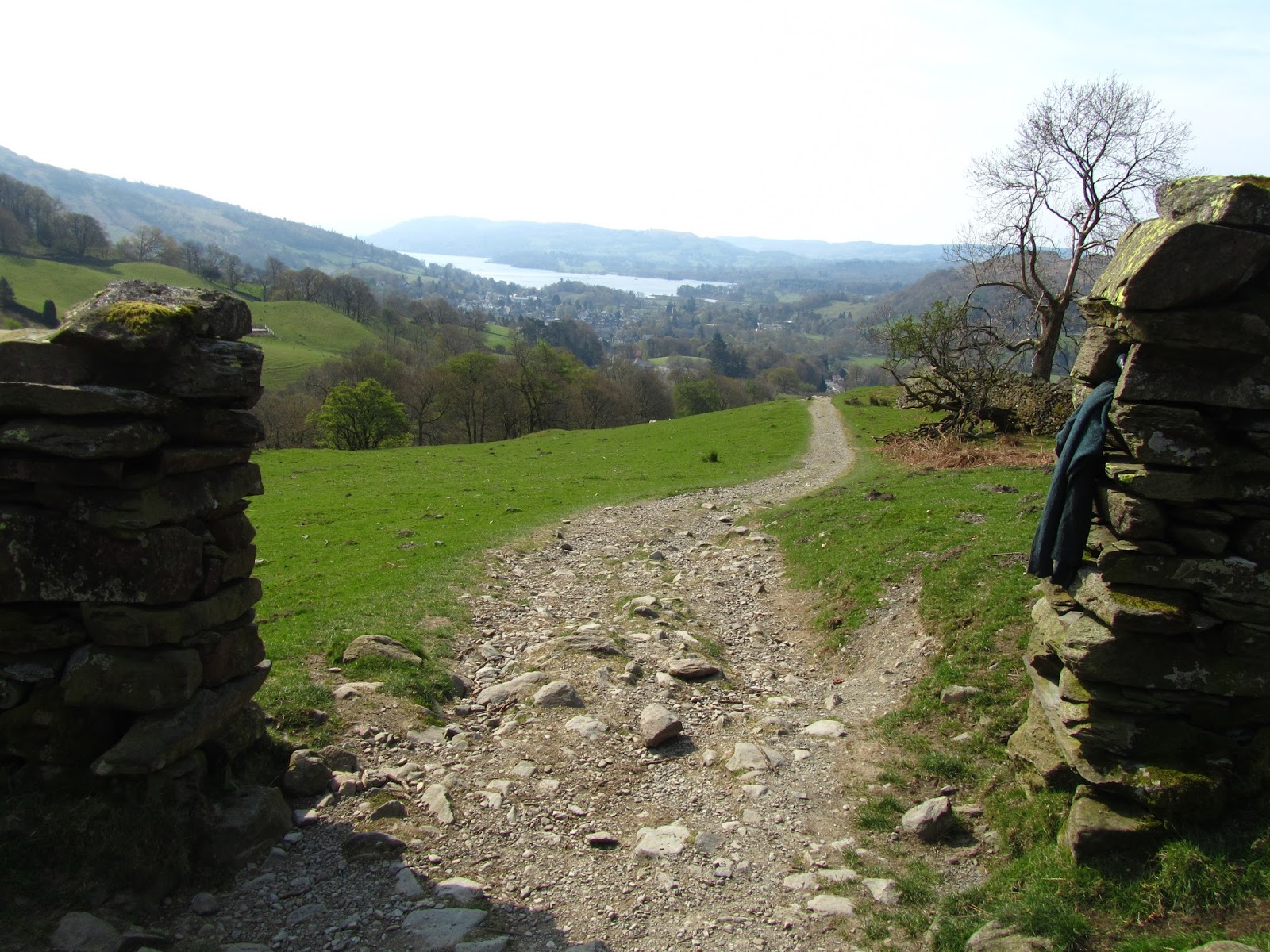
As we made our way up the slopes of Low Pike, the wind gradually picked up, but we still enjoyed its cooling effect and it helped us on our climb. Despite its name, as it's name suggests, this is not the highest of fells, and although easily reached, it is quite a sharp pull up, as you get onto the main ridge of this wonderful circuit.


From here navigation is made very simple by a dry stone wall that traces the route for the next few miles. This does restrict views somewhat looking forward, but with an increasing wind, it made for welcome shelter.


Clouds started rolling in, and it seemed that the weather forecast might have omitted some of the facts! The walk up from Low to High Pike is very impressive, with the next goal in clear sight as you gain altitude.


From here, much of the hard work has been done for now, as the path and accompanying wall march onwards over the summit of Dove Crag - which was the subject of the first ever chapter Wainwright wrote for his Pictorial Guides.


Somewhere along here, our faithful companion and wind shelter slowly dwindled away, leaving us exposed to the elements. The next fell on the horseshoe, Hart Crag is a short walk away, but by this time the clouds were rolling in. From here you have  choice to either continue towards Fairfield, or an alternative would be to head eastwards to Hartsop Above How and then down towards Brothers Water.


We pressed on towards Fairfield, at this point the winds were getting much stronger and we felt a few drops of rain - what happened to the weather forecast we were promised?!?! Conditions on the vast Fairfield summit platform were pretty bad so the camera didn't come out much except to take this shot down back into the valley.


We had planned on stopping for lunch, but after visiting the summit cairns and shelters we decided it would be better to head for lower ground, so on we marched onwards on the return leg of the horseshoe.


This is a very spectacular ridge and it's not hard to see why it is so popular, but today things were very quiet up here with the howling winds, and its fair to say we were glad it was a wide ridge rather than a narrow crest of rock!


Onwards and over Great Rigg and Heron Pike and there was no let-up, so not much of a chance to stop and take in the views.


Even on lowly Nab Scar we still had a howling gale to contend with, but we did manage to find a spot of shelter for lunch.


Soon enough afterwards, we were back down off the higher ground on the valley floor, where we stopped at the very picturesque tea shop at Rydal Hall for a warming cup of coffee.


The walk back to Ambleside route is a really nice lower level walk, and the perfect end to a spectacular if at times a rough day on the fells.

Sunday, 16 February 2014

Pike O' Blisco and Cold Pike

If it's been a while since we had a couple of days in Ambleside, it's been even longer since we visited Great Langdale. Taking advantage of a day pass on the buses for the Central Lakes area meant travelling at leisure, not having to worry about finding a parking space and best of all on this occasion it meant being able to sample a pint at the Hiker's Bar at the The Old Dungeon Ghyll Hotel, which is definitely one of the "must do's" in the Lakes.


This route takes in Pike O' Blisco and Cold Pike, exploring the southern fells of Great Langdale and offering fantastic views of the Langdale Pikes across Mickleden as we made our way up.


We took the route up Pike O' Blisco, via Wall End farm. This is an excellent route, a steady climb, along the Blea Tarn road and then a good path.


The scenery is varied meaning it stays interesting all the way. Not far from the summit are a couple of small scrambles which are fairly simple and fun to go up. Once we were on the summit, the wind picked up as usual.


There is a decent sized summit shelter, but a few people had settled in there and were looking very cosy and they didn't look like they were about to budge up and let us in, so after enjoying the views for a short time, we moved off the picturesque summit.


I sometimes wonder about fell etiquette - people who faff on taking endless pictures of the summit cairn or trig point, oblivious to any others patiently waiting to take a quick snap, or shelter hogs such as the crew we had just encountered.


Oh well, it was too windy for a picnic on high ground anyway, so we soon set off on the steep descent towards Red Tarn. The summit of Cold Pike had been shrouded in cloud for much of the walk so far but this was constantly shifting so we were hoping to to time the walk up to Cold Pike with a break in the cloud. From here we had some good views southwards towards the Coniston Fells.


Following the map and pictorial guide we somehow found ourselves on a path that was clearly non-existent, and headed across the marshy ground at the head of the tarn. We followed the wet ground straight up the side of Cold Pike and I am might suggest that on the forthcoming revision of the Pictorial Guides, that this fictional path be omitted!


We hit the high ground of Cold Pike and the cloud closed in again which made navigating this rocky summit fairly tricky. With three high points to choose from, I scrambled up a rock which I thought would be a summit, but soon realised there was plenty of higher ground around, so  - although fun - and we soon made our way onto the "real" summits.


The cloud and cold meant once again this wasn't a summit to linger on, but fortunately the path heading over to Crinkle Crags is unmissable.


We followed this good path to an obvious junction and headed back down to Red Tarn with good views back across to Pike O' Blisco, and rejoined the route down from Pike O' Blisco which passes Stool End farm. We stopped at a lovely spot for a bite to eat alongside the gushing waters of Browney Gill before continuing the steep descent.


The descent was enjoyable, as the views of Great Langdale are stunning, and each step offered a new reward.


Even on the valley bottom there were rivers, bridges, stone walls and even a couple of deer grazing in a field for us to enjoy. Our timing was perfect with the bus due in an hour, so we headed into the legendary Hiker's Bar for a pint and a reflection on a wonderful Winter walk.


Wednesday, 22 January 2014

Wansfell and Wansfell Pike from Ambleside

Ambleside always feels like a very welcoming place. With Loughrigg on the one side and Wansfell on the other it is safely nestled in and feels very cosy. The fells themselves are just as friendly, with easy access from the town and both offer a satisfying walk.


Wansfell has the added bonus of taking in the delightful Stock Ghyll Force waterfall on the way to the path up the fell.


With the number of daylight hours at their shortest in December, it is the ideal time to enjoy these lower fells which are straightforward to get to. We set off up the road towards Stock Ghyll Force just after lunch. The volume of rain which had fallen recently meant the falls were at full flow and as always were a joy to behold.


After the falls, the walk up to Wansfell Pike is an obvious and straightforward march up the path up the grassy slopes of the fell, with frequent stops to enjoy the vista opening up behind us. In particular the low sun cast some lovely light over Ambleside and beyond.


The weather took a brief turn for the worse when we reached the summit of Wansfell Pike, and we encountered a group huddled behind the wall hastily putting on their waterproofs. We had set off fully kitted out in winter gear so no need to stop as we headed alongside the wall that goes from Wansfell Pike to the fell summit of Wansfell.


This is a beautiful walk that feels very remote despite being a stone's throw away from Ambleside. The fell top was very quiet, the only people we passed were some hunt beaters, who it must be said did not look best pleased to see us! Oh well we were on a public footpath and enjoying the walk so we carried on the undulating path that took us to the summit cairn.


As per usual, as soon as the summit was in sight, the winds picked up and apart from a brief interval to snap a couple of pictures, we didn't hang around.


There wasn't a great deal of daylight left but we decided to vary the walk a little, taking a return route via the Troutbeck side of the fell before coming round back to Ambleside via The Hundreds, along Nanny Lane before passing through Skellghyll Wood.


The sunset provided some fantastic scenes across Windermere, which my camera sadly didn;t capture too well but this was a magical moment. It was getting quite dark by the time we reached the woods but not so dark that we needed to break out the headtorches.


Before we knew it we were back at our cosy bed and breakfast in Ambleside, happy with the gratifying walk we had just completed.

Thursday, 28 June 2012

A Windermere Wash-Out

Last weekend was set to be one of the highlights of the month - I had entered for the Great North Swim, booked into our favourite bed & breakfast in Ambleside, booked a table at the fab Zefirellis for the Saturday night and picked out a number of walks for the Saturday afternoon and Sunday morning.

a dismal looking Helm Crag

As can happen with mother nature and the Lake District come head to head, it wasn't to be. I got the news on Friday afternoon that the swim was cancelled, but seeing as the rest was already booked Claire and I thought we'd make the most of it and enjoy a weekend in the Lakes - it takes more than a spot of rain to deter us! But doubts were setting in on the horrendous drive over on Friday night, with parts of the A66 flooded not to mention the side roads such as the one to St Johns In The Vale looking unpassable.

heavy clouds over Thirmere taken from the car

 After a nice night out in Ambleside, the weather on the Saturday morning was no better! I always look for the silver lining as you may have noticed, so as we decided to cut our trip short, we made a detour to Booths in Keswick for some walking magazines and Lakeland ales, as well as a stop at the rather nice Rheged Centre just outside Penrith where we had a look and the shops and enjoyed the photo gallery on display which included several pictures from my namesake Tom Chapman!

the goodies!

Thursday, 27 October 2011

Rydal Water and Rydal Cave

The Lake District is famous for many things. One of the less popular of these is the infamous Lakeland weather - rain one minute, bright sunshine the next. Well I was hoping that on our mini honeymoon the weather would be kind, but alas on this recent October excursion, it was the rain that dominated.


With this in mind and the newly purchased "Lake District Wet Weather Walks" by Christopher Mitchell wrapped in a waterproof package under arm, we headed out for a walk around Rydal Water, instead of the planned Central Fells. The guidebook we were using is extremely informative and points out all manner of flora, fauna, minerals and rocks that you pass as you walk. This proved to be a wise decision, as the weather went from a slight drizzle to a constant downpour that soaked right through my recently re-waterproofed jacket, hmmm....


Setting off from White Moss Common car park, the walk started off alongside the turbulent river Rothay, before crossing a large footbridge.


We then entered woodland - first bonus of the wet weather walk guidebook has been noted - and walked among the large trees until we reached a gate that lead us onto the lower slopes of Loughrigg Fell.


The guidebook we were using is extremely informative and points out all manner of flora, fauna, minerals and rocks that you pass as you walk.


This led us to one of the highlights as we approached Rydal Cave. This huge quarry hole is very impressive, with pool and stepping stones inside, or indoors if you prefer. After a brief exploration, the  next surprise was just down the path as we came across a further quarry. It's always amazing to discover how so much of the countryside that looks as natural as can be is the result of man's use of the land.


With the rain coming down harder and harder, at this point we stopped following the guidebook, not wanting to take it out of its waterproof home. We headed downhill until we reached the water's edge. Despite the poor conditions the views of the lake and surrounding fells still had that mesmerising effect.


We faced a small challenge walking back along the waterside when a short section of the path was most definitely underwater, so a short muddy scramble was required.


From here it was a simple route back until we rejoined our path at the woods before crossing the Rothay once again. This was a very pleasant scenic route that meant although the weather didn't exactly encourage taking to the outdoors, we managed a great low level walk. Glad to get back to the car though at the end of it!

Tuesday, 12 April 2011

Best of 2010 Part 6: Wansfell from Ambleside

the lower falls at Stockghyll
This was a nice short walk  from Ambleside up Wansfell via Stockghyll Force, which served a number of purposes apart from being a great ramble:
  • It was a perfect "day off in between longer walks"
  • It bagged us another Wainwright fell
  • We only had half a day spare
I could think of a ton more reasons, the most obvious being "it was there begging to be climbed", so thats what we did. It also marked my first foray into Wainwright's Far Eastern Fells, so well worth checking out.

The walk started off in Ambleside town centre, heading up along the road leading to Stockghyll Force. The pictures of the falls were taken on another walk I did with Claire in the Autumn.


After missing the blindingly obvious path past the falls, crag rat Rainer and myself soon found ourselves at the bottom of Wansfell, and looking up it didn't seem to far.

looking up at Wansfell Pike

The walk up the fell was quite a slog, albeit a short one.  But that's where the Wainwright geek in us took over and we just stopped for a short while at Wansfell Pike.

the path from Wansfell Pike to Wansfell

Instead of following the tourist route to Troutbeck we headed north-eastwards, following the undulating wall over to the summit of Wansfell proper. We had some fantastic views from here over the Kirkstone Pass to Red Screes and the fells beyond

Wansfell summit

Despite the crowds that were on Wansfell Pike we had the summit of Wansfell to ourselves - as well as the natives of course as pictured here.


We picked another route back down which took us right to the shores of Lake Windermere, the best picnic spot of last Summer in my opinion.

Coniston fells in the distance over Lake Windermere