Showing posts with label Swaledale. Show all posts

Sunday, 22 June 2014

Walk To Work on the Coast To Coast


I recently heard of a walk to work week initiative, and this gave me the perfect excuse to trek a section of the coast to coast, since my office is very close to the route!


It was a simple enough walk from Richmond to Colburn, a distance of about 4 miles each way. Whilst this section of the C2C is not as spectacular as some of the others, it is pretty and has a charm of its own.


Leaving Richmond Station along the old railway path, you catch glimpses of Easby Abbey through the trees. Shortly after the C2C leaves the rail path and climbs through fields to a patch of woodland on the banks of the river Swale.


This is a lovely little woodland walk and at this time of year the scent of wild garlic was heavy in the air.


As you climb out of the woods and back into fields and farmland there are occasional glimpses across valleys deep into the Yorkshire countryside. Soon enough I reached the charming village of old Colburn and the end of my walk, only to enjoy the same route in reverse at the end of the day.


Who would have imagined that the commute to work could be so good!


Saturday, 8 June 2013

Muker Meadows in Swaledale

Swaledale is a pretty special place for me. Working in Richmond, I often see walkers when I stop for a coffee before work, knowing that most of them are well into their Coast To Coast adventures. Heading further up into Swaledale you go though some spectactular places - Reeth, Gunnerside and Muker are all great starting points for walks.


We recently had visitors and so we decided to head over to Muker to have a look around the village and the wild flower meadows that you cross when heading up on the paths towards Keld.


After the long cold Winter that we had,it will be a while yet until the meadows are in bloom, but here Swaledale is really spectacular as it gets gradually narrower as it heads towards Keld. This is also where two walking legends cross - the Coast To Coast and Pennine Way routes cross just a short distance to the north of the village.


Our plan for the day was to take in a number of Dales sights - a drive across the Buttertubs Pass, visit to the Wensleydale creamery and a whistle stop tour of Leyburn, so our walk was just a quick one here. Despite the sun being out, it was pretty cold and at one moment it even started to snow - not what you expect from late April!


But whatever the weather, this is a spectacular location looks great at any time, with the meadows, barns, stone walls and the hills creating a fantastic surrounding.


Saturday, 25 May 2013

River Swale at Richmond

I was in Richmond town centre early one weekend recently whilst working on another project and so I thought I'd make the most of it with a quick castle walk. Part way round though I decided to take the steep steps down and do the walk round at river level.


I normally stay up on the high path but down at the riverbank you really get a good impression of how the castle dominates the landscape.


This really is a lovely place to walk - even though you are just minutes from the market place this feels far removed from anyone and at this time of day the only sound was the water rushing by. For those having a short break whilst on the Coast To Coast this is well worth having a look.


Even in the shallow fast-flowing river, an odd bend allows the water to slow right up providing a tranquil scene.


And the falls are always a good viewing point as the water cascades only a metre or two but it is always a compelling scene. Like sitting round a campfire gazing into the flames, somehow I never get bored of looking at the water hurtling over the edge of the falls.


A quick sharp walk uphill and I was back at the market square, the walk is literally only ten minutes, but sufficient to put a smile on my face for the rest of the day!

Thursday, 30 August 2012

Marske, Marrick and Lower Swaledale

Here is a recap of a walk I did shortly before breaking my ankle. I've been slowly making my way around Swaledale this year as it's an incredible valley that packs so many delights and hidden gems - Gunnerside Gill, Calver Hill, Crackpot Hall and its commandeering view over the steep head of the top of the valley, the ruins of its industrial legacy just to mention a couple.


We took the road along the top of the valley from Richmond to Marske which is scenic enough in itself. The tiny village of Marske is a great starting point for a number of hikes. Our walk on this nice Summer's day was a circular route from Marske to Marrick and back and is another walk in Paul Hannon's excellent "Swaledale" walking guide. You can pick this book up in most good walking web stores, for example in the excellent Walking Boots webstore. (Note: No affiliation)


We headed out of the village a short way along the minor road towards the Richmond-Leyburn road before heading off across the fields. This offered a great view of Applegarth Scar, the cliffs of Side Bank Wood leading up to Downholme Moor and our first glimpse of the river Swale.


Looking back we could see the pastures and lush fields that surround Marske and the impressive clock tower of Marske Hall. We crossed the minor road at the historic Downholme Bridge.


The next part of the walk saw a change in the landscape. We left the lush pastures behind us and with the river Swale accompanying us on our left, we slowly climbed up onto higher ground in the valley giving us extensive views across the moorland of Swaledale and it was an impressive view indeed.


The great views continued all the way past the recently renovated Marrick Park and a restored double limekiln, all the way to the village of Marrick. Much like Marske, this picture postcard village is a beauty and seems to be lost somewhere in time.


Our return route followed the Coast To Coast route. We climbed back up out of the village onto the meadowland and this meant some classic Swaledale scenery, big meadows and stone barns.


I love this aspect of the Dales, wide open undulating meadows that offer massive views from the tops and images of a beautiful working landscape wherever you look, with sheep, barns, haybales, drystone walls and farms all around.


From here it was a simple if at times steep walk back down through the fields and onto the road taking us back to the car at Marske. Once again it was a pleasure to explore the diverse scenery that Swaledale has to offer.


Thursday, 17 May 2012

Swaledale's Mining Legacy

Some of my recent walks have taken me along some of the finest scenery in the Dales and at the same time shown me a great deal of Swaledale's industrial heritage. I thought I'd take this opportunity to take a closer look at some of these historic sites. Far from being an expert, I found these places really interesting and I thought I would share some information and images with you.

Crackpot Hall

Crackpot Hall overlooking Swaledale

I have been interested in exploring the ruins of Crackpot Hall ever since learning about it from Julia Bradbury's Coast to Coast programme. This is not only a really interesting building complete with outhouses but it offers some really spectacular views along Swaledale. The buildings had been used as a shooting lodge and farmhouse but have stood empty since the 1950s.  For more information read http://en.wikipedia.org/wiki/Keld,_North_Yorkshire

Crackpot Hall plaque unfortunately missing!

Swinner Gill Lead Mines


At the point where Swinner Gill and East Grain meet, the footpath crosses a small stone bridge and beneath the bridge you can see how the rocks have been polished slick by hushing, which was a method of mining that used water to reveal mineral veins. As we stopped to take a couple of pictures a fellow walker told us about a cave further up the gill at Swinnergill Kirk that served as a place of worship for Catholics at a time of religious persecution. Here is a walk report in the area for you to read on the excellent Walking Englishman website: http://www.walkingenglishman.com/dales4.htm


Blakethwaite Smelt Mill


I have visited this site twice now, but I think it will remain a sight that I could never tire of. The arches that remain would be just at home on the site of an ancient abbey such as Easby or Egglestone as they are here high up Gunnerside Gill. The kiln is still fully intact and also looks like it was built as part of a castle rather than for the smelt mill. This site started its working life in 1821, smelting ore from the Blakethwaite and Lownathwaite mines.

looking up to the kiln


Old Gang Smelting Mill


Coming round a corned along the bridleway heading from west to east, the approach to Old Gang Smelting Mill is an impressive one - evidence of the mining past is all around as you spot a tunnel here, another level there before spying the collection of buildings in the distance. It's quite amazing to think the network of tunnels stretches all the way back to Gunnerside Gill. There is a lot still to see here with the tall chimney dominating the scene. There is a good walk described in Paul Hannon's "Walking Country - Swaledale" book which takes in this site and offers plenty of background information.


Surrender Lead Smelt Mill


Dating from around 1840, this old mill and peat house is not too far from Surrender Bridge. It is a grade 2 listed building and was built to replace a mill from 1680. For more information about the mines of Yorkshire have a look at this excellent site: http://www.martinroe.pwp.blueyonder.co.uk/

High up on the moors heading towards the Old Gang Smelting Mill on what is almost a lunar landscape we came across this disused stone-breaking machine, I wonder if it has been left up there as a momento of an industrial time gone by?


This article goes into much more detail about the lead mining history of the northern Dales and is well worth a read: http://www.outofoblivion.org.uk/lead.asp

Thursday, 3 May 2012

Walking with the Guardian

Here's a quick note to say I have published a walk report on the travel pages of The Guardian website which can be viewed here.


This is a short version of my recent Swaledale adventure, and I hope to build up a collection of articles on this site. Most posts on there are fairly short, and of course as with all sites that are comprised of recommendations, some of them need to be taken with a decent pinch of salt!

Having said that, there are plenty of tips in all manner of categories, from places, to parks, to restaurants and shops, and it's a good place to pick up ideas for any travel plans you may have.

There is currently a really interesting feature on the Guardian's travel site about exploring the North Yorkshire Moors which is well worth a read: http://www.guardian.co.uk/travel/series/holiday-guide-north-yorkshire-dales


Thursday, 19 April 2012

Keld to Reeth on the Coast 2 Coast

Here continues our epic Swaledale one-dayer (for part one click here), which took us from the top of the moors at Tan Hill to the centre of Swaledale and the village of Reeth.


This was a day of varying landscapes and I think that made it a really interesting walk.

We pick up at the decidedly fairy-tale picturesque site of East Gill Force, where we stopped for a bite to eat. This is one of the many perfect picnic spots we were to see today!

looking over Crackpot Hall down Swaledale

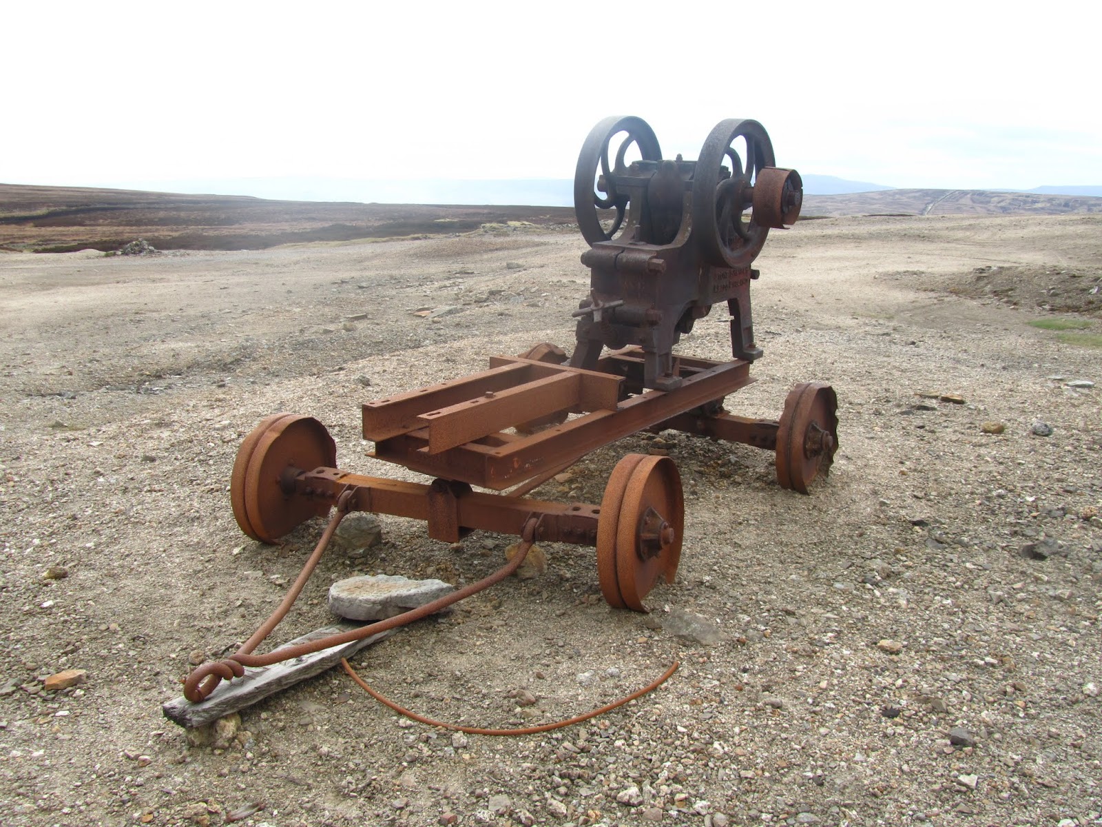
We headed upwards off the valley path to take in the 18th century ruins of Crackpot Hall. This reminds me, look out for a forthcoming post about Swaledale's industrial past! We had a large walking party ahead of us so there was no need to work out the route, just follow the crowd as they headed up Swinner Gill, past the old lead mine and up East Grain. The skies had clouded over and a steady drizzle was getting us slowly soaked through, but fortunately this soon gave way to much better weather.

one of the Swinner Gill waterfalls

This was a steep little climb up to the head of the gill passing a number of waterfalls, before a complete change of scenery on the tops of the moors. This section reminded us of the railway path section on the Lyke Wake Walk, with nothing but moors in site for miles around.

the upper moors between Keld and Gunnerside Gill

Soon enough we reached Gunnerside Gill, and a climb down brought us out at Blackthwaite Smelt Mill. After a bit of a poke about at this very interesting site we headed upwards to the head of Gunnerside Gill.

the head of Gunnerside Gill

Again this brought us out onto the tops of the moors and a couple of miles of walk along a bridleway, once again taking us past many relics of Swaledale's industrial past. The most spectacular of these was the remains of Old Gang Smelting Mills.

Old Gang Smelting Mills

By now the sun was out and we had warmed up nicely. With the sun out the colours of springtime in the Dales become totally vibrant, with the lush green fields, blue rivers and streams, bright daffodils and specks of white of the newborn lambs dancing in the fields all around.


We came down past Surrender lead smelting mill and this brought us into the almost alpine scenery alongside Barney Beck. This tiny path follows the stream before heading up into the fields and offering once again some fantastic views. Calver Hill came into view before us, this being the hill that stands guard over Reeth, so the end of the walk was not too far away.

Calver Hill

We still had a fine stretch to go, by finally rejoining the river Swale just before the village of Healaugh. Good paths on both sides offer a fantastic riverside walk, with the added fun of stepping stones before fiunally crossing back over to the Reeth side of the river over the suspension bridge.

stepping stones over the river Swale

A final short pull up the hill brings you back to the village green and pubs at the heart of Reeth, perfect!

the square at Reeth

Wednesday, 11 April 2012

Tan Hill to Keld on the Pennine Way

Computers eh sometimes you love them, sometimes..... they delete your work for no apparent reason - so here goes, my second write up of this walk!

Tan Hill Inn

As part of our mission to do as many challenge walks as time constraints permit this year, for this month I had decided to do a big Swaledale challenge. I decided to combine two classic long distance paths, taking the Pennine Way down from Tan Hill to Keld and then heading over on the Coast to Coast to Reeth.


We had originally planned to do this the other way round ending up at Tan Hill but unfortunately the bunk barn was fully booked up. I have never been to Tan Hill and Claire is a big fan having been several times on work outings and made firm friends with the pub lamb, Spotty Muldoune!

Nine Standards Rigg in the distance

We parked up at Tan Hill and headed off southwards on the Pennine Way. It was to be a day of changing weather and landscape, and as the pictures show we started off dry but overcast, with vibrant colours across land and sky. From the tops of the moors we had huge views, to the northern Pennines over the A66, westwards to Nine Standards Rigg and with some of the iconic Dales fells visible to the south.

A Swaledale stone barn

The recent dry weather meant that this crossing of the moors was springy rather than boggy and a real pleasure to walk on. Soon enough the pub was just a speck in the distance behind us, and we were in remote territory, with the occasional stone barn for company. Down to the right of us was a tiny road winding its way along the Dale along a little beck where I spotted this packhorse bridge.


Keld soon came into sight, nestled beneath the rounded slopes of Kisdon fell. And with Keld came the switch from the Pennine Way to the Coast to Coast, heading easterly instead of to the south. Coming down the brow of the hill we were rewarded with a fantastic view down the head of Swaledale, surely one of the finest views in the Dales.

Kisdon

Stopping at East Gill Force (thanks to Gary Richardson for the correction! Please look at Gary's fantastic Wainwrights website here) we will pick up on this walk next week. Be warned the weather takes a turn for the worse, so make sure you pack your hat and gloves for the read on!

East Gill Force