Thursday 27 October 2011

Rydal Water and Rydal Cave

The Lake District is famous for many things. One of the less popular of these is the infamous Lakeland weather - rain one minute, bright sunshine the next. Well I was hoping that on our mini honeymoon the weather would be kind, but alas on this recent October excursion, it was the rain that dominated.


With this in mind and the newly purchased "Lake District Wet Weather Walks" by Christopher Mitchell wrapped in a waterproof package under arm, we headed out for a walk around Rydal Water, instead of the planned Central Fells. The guidebook we were using is extremely informative and points out all manner of flora, fauna, minerals and rocks that you pass as you walk. This proved to be a wise decision, as the weather went from a slight drizzle to a constant downpour that soaked right through my recently re-waterproofed jacket, hmmm....


Setting off from White Moss Common car park, the walk started off alongside the turbulent river Rothay, before crossing a large footbridge.


We then entered woodland - first bonus of the wet weather walk guidebook has been noted - and walked among the large trees until we reached a gate that lead us onto the lower slopes of Loughrigg Fell.


The guidebook we were using is extremely informative and points out all manner of flora, fauna, minerals and rocks that you pass as you walk.


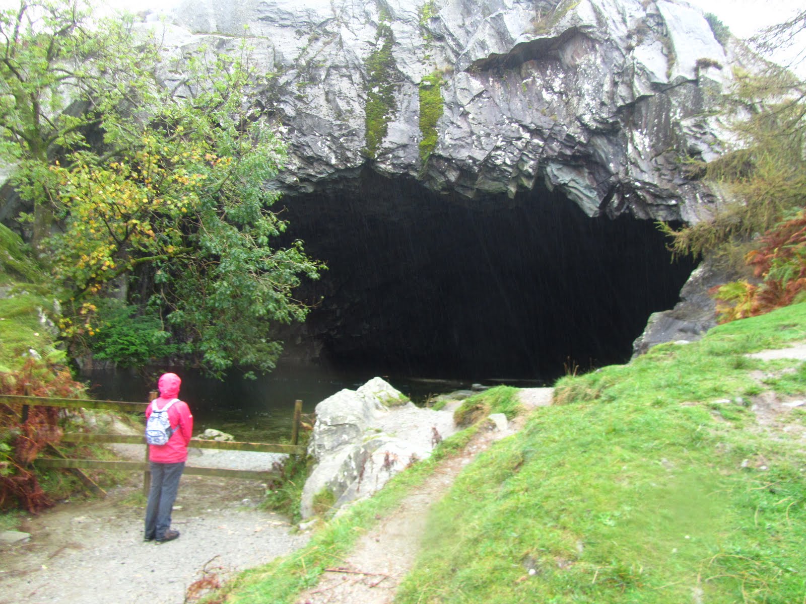
This led us to one of the highlights as we approached Rydal Cave. This huge quarry hole is very impressive, with pool and stepping stones inside, or indoors if you prefer. After a brief exploration, the  next surprise was just down the path as we came across a further quarry. It's always amazing to discover how so much of the countryside that looks as natural as can be is the result of man's use of the land.


With the rain coming down harder and harder, at this point we stopped following the guidebook, not wanting to take it out of its waterproof home. We headed downhill until we reached the water's edge. Despite the poor conditions the views of the lake and surrounding fells still had that mesmerising effect.


We faced a small challenge walking back along the waterside when a short section of the path was most definitely underwater, so a short muddy scramble was required.


From here it was a simple route back until we rejoined our path at the woods before crossing the Rothay once again. This was a very pleasant scenic route that meant although the weather didn't exactly encourage taking to the outdoors, we managed a great low level walk. Glad to get back to the car though at the end of it!

Thursday 20 October 2011

The Langdale Pikes

Despite poor weather forecasts and the prospect of not finding a parking space due to the Langdale fell run being held on the same day, Claire and I took our chances and went for an exploration of Great Langdale valley and a walk up the Langdale Pikes.We clearly made the right decision, with only a few vehicles in the car park at New Dungeon Ghyll - perhaps others had been put off by the factors as mentioned.


The drive from Ambleside was a spectacular one past Loughrigg Tarn, Elterwater and through Church Stile, and gave plenty of ideas for the next rainy day/ non walking day in the Lakes.
The Langdale Pikes were swathed in cloud, although it was fairly windy so the cloud moved quickly, offering us glimpses of the path ahead.


 With the Central Fells guide in hand, Wainwright showed the way and it was a great route to follow via Pike Howe, passing streams, crags, waterfalls and with views all along Great Langdale.

Pike Howe
We headed up to Pike Howe and as always in the Lakes, each step offered an ever widening panorama behind us and soon enough we had a great view down the valley all the way back to Windermere.

looking back down Great Langdale towards Windermere

 After the Pike we were on the grassy plains and if we had had more time then it would have been well worth making the detour to view the cliffs of Pavey Ark over Stickle Tarn.

finally the tops of the Langdale Pikes start to reveal themselves
After the grass came the scree, and with the scree came the cloud and rain, and all of a sudden the going got much tougher. At times the cloud was very thick and it was easy to stray from the path, but fortunately we made it up to the top of Harrison Stickle with no problems. 

Harrison Stickle is up there somewhere

As with all summits on this walk, they were shrouded in mist and cloud, and the spectacular views they offer were to remain hidden all day. At least that gives us good reason to revisit the area.

Harrison Stickle summit

Coming down from Harrison Stickle we were tempted to break off the walk as the weather wasn't improving, but once we were back on the high level plains and marshes that connect the peaks of the Langdale Pikes, things were looking up and we could just about make out Pike O'Stickle in the distant cloud.

Pike O'Stickle from the slopes of Harrison Stickle

The walk across was pleasant enough with stepping stones coming in handy over the occasional marshy patches of ground. It was a short walk to the base of the Pike O'Stickle summit, with a pause at a steep gulley to enjoy the view before making the final scramble to the summit.
the view coming back off the summit of Pike O'Stickle

Once again, the tiny summit offered nothing in way of sights to see, so after a short pause we scrambled back down to the gulley for our lunch.


With no let up in the cloud we were fortunate to have the guidebook and map giving a good explanation of the route.

a ghostly Loft Crag

Finally Loft Crag appeared and it was an easy and pleasant walk to the summit. Although we were still up in the cloud there was a brief respite that gave us anewed views over the Great Langdale Valley over to Lingmoor Fell and Tarn and with the Coniston range in the distance.

fantastic view across Great Langdale to Lingmoor Tarn
The weather gradually deteriorated as we came down from the fell between Glimmer Crag and Thorn Crag, occasasional promises of break in the cloud soon gave way to cloud, mist and fine drizzle that accompanied us for most of the way.

looking over to Pike Howe coming off Loft Crag

Pike O'Blisco through the clouds

We did get some fantastic views back up to Harrison Stickle as we headed down towards the Great Langdale Valley.


Despite the poor conditions it was a spectacular walk in an area of the Lakes I'm sure we will visit time and time again.

Thursday 13 October 2011

Semer Water

"Semerwater rise! Semerwater sink! And swallow the town, all save this house, Where they gave me meat and drink."
Semer Water is a beautiful and quiet location, in fact I was amazed at how few people I encountered on this walk on what was the last weekend of the school Summer holidays.It is also home to a legendary city that was drowned by after an old man visiting the town was turned away from all but one house - that one house on the hill was saved from the watery grave.


After a number of trips to the Lakes recently, I though it was about time I paid a visit to the Yorkshire Dales again. I decided on visiting Semer Water and the surrounding Dale as the route description in my AA guide to the Yorkshire Dales sounded promising.


It was also not too far away, and seeing as I had a busy day planned this sounded about right. The drive in itself is really enjoyable as you come through Wensleydale turning off the main road just before Bainbridge.


The walk started right on the lake shore and was a great place to start. I headed up the road to a farm before crossing a stile and heading out across the meadows. There was a lot to see here, with the head of Raydale up ahead and the lake to the right. I stopped for a brief look around the ruins of Stalling Busk church and small graveyard.


From here the walk led away from the lake and into the Dale reaching the village of Marsett before long. By now the sun was emerging from the clouds and was casting shafts of light onto the surrounding daleside.


Leaving Marsett meant a steep climb up 250 metres. This was well worth the effort as the top rewarded me with some great views of Semer Water and the distinctive shape of Addleborough behind reminiscent of Ingleborough, and on the top of the open access land there were views westwards all the way over to the Yorkshire Three Peaks.


I didn't cross a single other person after having left Marsett and up on the Dale I certainly felt cut off from the rest of the world, with only countryside and the occasional farm in site. The path came back down slightly more gently than the hike uphill and soon I was on the road leading back to Semer water.


It was even quieter there than when I arrived, with maybe two or three cars parked, with people reading, drinking cups of tea and enjoying the serenity, the only noise came from the ducks on the edge of the water. All in all a really nice moderate walk and definitely one to repeat.

Thursday 6 October 2011

Married!

This is a post to say that this week there are no posts - walking posts that is. My beautiful Claire and I got married at the weekend, and it was a fantastic event at Redworth Hall in spectacular County Durham. As well as attending our celebration some of our guests have been enjoying the spectacular scenery of the region, at Salturn-by-the-Sea, Aysgarth Falls, Richmond Castle and the river Swale passing through the town, and explorations in the Yorkshire Dales.

More walking next week!